Marrakesh
The city is also blessed with an ideal location. Just one hour away from the heat and the crowds of the city, you can be strolling through the High Atlas foothills of the Ourika Valley, or striking off into the wilder territory around Mount Toubkal, barely visited except by the animals and their Berber shepherds.
Valleys cut through the range and spill out south and east towards the Sahara. Dot ted with red-coloured kasbahs, riotous palm groves and largely unremarkable towns, the spectacular natural settings exemplify the maxim that ‘it is better to travel than to ar rive’. The best time to visit is undoubtedly early spring. If you can, avoid Marrakesh during the months of July and August.
THE TOUBKAL TREK
Most people leave Imlil early in the mor ing for the five or six hour walk to the Toubkal (Neltner) Hut. Head up the main street of the village and then follow the mule track on the west side of the Mizane River to Aroumd. From here the trail fol lows the east side of the river, reaching the village of Sidi Chamharouch a couple of hours further on. Bottled drinks are usually available at both these villages.
The trail then climbs steeply and clearly up to the Toubkal Hut (3207m), which sits at the spring snow line. The stone cottage was built in 1938 and has beds for 29 peo- ple in two dormitories (you need your own sleeping bag). There’s also a kitchen with a gas stove and a range of cooking utensils; hot water is available.
The charge is 52 DH per person for non- CAF members, plus an extra charge if you use the cooking facilities or need hot water. The resident warden will let you in. You must bring all your own food with you, as there’s none for sale. The warden may, you give him plenty of notice, prepare if meals for you. Don’t turn up at this hut without a booking in the high season or you may find it full (one reader also suggested bringing ear plugs). There are plans to build a second refuge near by.
The ascent from the Toubkal Hut to the summit (up a lot of exhausting scree slopes) should take between three and four hours and the descent about two hours. The South Cirque route is the most straightforward one and starts just behind the refuge. It’s worth setting off as early as possible to gain the best chance of clear views from the top.
It’s best to take water with you. Any water from mountain streams should be treated with purification tablets or there’s a fair chance you’ll pick up giardiasis. It can be bitterly cold on the summit, even in sum- mer, so bring plenty of warm clothing.
OTHER TREKS
The following suggestions cover just some of the possibilities for longer treks in the area. You are advised to hire a guide and mules for all of them. Some routes have been suggested by an old hand in the High Atlas, Rick Crust, and others by guides based in the Imlil area. The first three routes are only really feasible in the spring.
Toubkal via Tazaghart
To do a longer circuit (four to five days) that gives you the option of taking in Toubkal, you could head south-west from Imlil over the Tizi Mzik to the village of Tizi Oussem (five hours) where there are two very welcoming village gîtes.
The following day, a harder trek takes you up the Azzaden Valley to the Taza- ghart (Lepiney) Refuge. There’s good rock climbing (for the experienced only) around Tazaghart and climbers often base themselves at the refuge. Options for the next day include scram-bling up to Tizi Melloul (about four hours from the refuge) and then on to the vast and desolate Tazaghart Plateau (3843m). Be sure to leave early in the day so you can get back to the Tazaghart Refuge before dark.
will need a guide for this. From the Tazaghart Refuge, you could also head east to the Toubkal refuge via the Tizi n’Taddate this is hard going, but worth it. Again, a guide is essential. The track is too steep for mules, but they can be sent back the long way round via Imlil and will probably arrive at about the same time. The following day you could climb Toubkal itself and return to Imlil via Sidi Cham- harouch and Aroumd.
Oukaïmeden to Setti Fatma This option (three or four days) starts from the ski resort of Oukaïmeden (see the Ourika Valley entry in the Around Mar- rakesh section). There are no mules to be hired here, but if you contact the CAF refuge or Hôtel L’Angour-Chez Ju Ju from Marrakesh a few days in advance you can arrange to have mules waiting for you.
You will need to bring all your own sup- plies with you from Marrakesh as there are no food shops at Oukaïmeden.
The first day is an easy walk (about four hours) down to Tacheddirt. There’s a good CAF refuge here with panoramic views where you can stay for Dr40 plus Dr5 if you want to use the gas for cooking. The warden is helpful and can supply bread and eggs. It’s a beautiful place and very relaxing (there are many other options from here, such as trekking down to Asni or Imlil and from there on to Toubkal).
The beautiful route from Tacheddirt to Setti Fatma follows a well-used mule track the entire way and offers some stunning views. The second day’s walk takes you up to 3616m then down to the village of Timichi where there’s a gîte. The third day involves a breathtaking descent down the Ourika Valley to Setti Fatma.
There are several accommodation op- tions in the village and an important moussem takes place here in August. You can head back to Marrakesh from here by grand taxi (15 DH).
Eight Days from Imlil
Local guides can suggest several routes that could keep you going for eight days or more. You’ll need plenty of provisions and camping gear.
One such route would take you in the first two days to the Toubkal summit. On returning to the refuge you then push south- east over Tizi n’Ouanoumss to Lake Sidi Ifni, one of the largest lakes in the Atlas.
The third day would see you heading on eastwards to the village of Amsouzerte. There are village rooms and a camp site here. From Amsouzerte, a demanding two day hike northwards would get you to the Tacheddirt CAF refuge. You can camp the intervening night at Azib Likemt.
You have a few options from Tacheddirt. One of them is to head north to Oukaïme- den. A couple of tracks and passes lead you from there to the south-west. On this circuit you would go via the Tizi n’Oukaïmeden down as far as the village of Amskere. From there you could easily finish off the walk on the eighth day by heading to Imlil either via Ikkiss and the Tizi n’Tamatert, or south-west to the main Imlil-Asni road over the Tizi n’Aguersioual.
If you wanted to prolong the walk by a few days, you could either proceed from Aguersioual to Matate (there are village rooms here) and drop south to the Tizi Mzik and on to Tizi Oussem, or do the same from Imlil. From Tizi Oussem you could turn north for Irkoubeline. On the final day you could retrace your steps to Imlil, or proceed to Tinitine (Imlil-Asni road) via the Tizi n’Techt and then down to Imlil.
Winter Walks
The following three treks (ranging from three to six days, or longer if you have time) have been recommended by local guides as good winter possibilities. As with the other suggestions, you’ll need a guide and a mule to carry supplies (and plenty of woollies). The first is a three day loop from Imlil.
On the first day you climb east for three or four hours, spending the night either in the pleasant Tacheddirt Refuge or in the nearby village of Ouansekra.
The following day is spent walking north-west along a river valley dotted with tiny villages. The night is spent in village homes in either Arg or Imska. The next day takes you on a long trek south-west to Tizi Oussem, where there’s a comfortable gîte. In the morning you can head back to Imlil via the Tizi Mzik (about five hours).
The next option is a five or six day trek from Asni or Imlil to Tin Mal. If you plan continue to Taroudannt from here, it’s ideal.
The starting place, Imi Ourhlad, is about halfway between Asni and Imlil, just to the west of the main road. The route takes you south-west through the pretty Agoundis Valley via the villages of Tiziane, Tizgi and Ameslane. Tizi Ameslane is probably the highest point of the walk at 2059m. From here you wend your way down the valley to ljoukak on the Tizi n’Test road. You’ll find some grocery shops, basic cafes, rooms to rent and a hammam here, Market day in Ijoukak is Wednesday.
From Ijoukak you’re within striking dis- tance (8km south-west) of the beautiful Tin Mal Mosque. Local buses stop at Ijoukak en route between Taroudannt and Mar- rakesh – check the times with the locals.
A third short winter walk, which covers a good range of terrain, takes you from Imlil to Tizi Oussem and then further west to- wards the Ouigane Valley and the Nfis gorges. Three or four days of fairly easy walking will take you to the seldom-visited Plateau du Kik via Tassa Ouirgane, Tizi Ousla and the village of Tagadirt. From the plateau, you can return to Asni.
Every thing you should know about 5 Places to Stay in High Atlas
Places to stay in High Atlas – Trekking
A good places to stay in High Atlas for trekking is the Club Alpin Français (CAF) Refuge right on the village square. It offers dormitory-style accommo- dation for Dr20 (members), Dr30 (HI members) and Dr40 (non-members). It also has a common room with an open fireplace, cooking facilities (Dr5 for use of gas), cut- lery and crockery. It’s possible to pitch a tent here, too.
Bookings for refuges (huts) further up can no longer be made from here, but in- stead must go through the CAF ( 270090; fax 297292), BP 6178, Casablanca 01, or through CAF, BP 888, Marrakesh. This could be awkward in summer without lots of forward planning, so you might have to be prepared to sleep out. However, guides and local people are often more than will- ing to put you up for about what you would pay in the refuges.
The Oukaïmeden, Toubkal and Taza- ghart (Lépiney) refuges cost Dr26 (CAF members), Dr39 (HI members) and Dr52 (non-members). Prices at the Tacheddirt refuge are the same as the Imlil refuge. You need your own bedding.
Back in Imlil, there are several other ac- commodation options. The best deal is the Hôtel L’Aine, which charges Dr30 per per- son in quite comfortable and bright rooms. It’s the first place you pass on your right as you enter the village, and has a pleasant tea- room stacked with all sorts of ancient books. Some of the rooms are set around a small garden, and you can sit up on the roof for some private sunbathing. There is a hot shared shower and basic meals are avail- able.

Near the Hôtel L’Aine, the Café Tafraout (390653 in Marrakesh) has rooms with shared hot shower for Dr30/60. They also have a small, basically equipped house to rent which costs Dr400 for up to 10 people. The Café Aksoual, on the main street virtu- ally opposite the CAF, has fairly basic rooms for Dr25. The showers are cold.
On the little square is the Café Soleil (319209 in Asni), now rebuilt after being washed away in the floods of August 1995. Pleasant basic rooms with shower and small balcony cost Dr40/70. One room that sleeps four costs Dr25 per person. There’s a ter- race downstairs and a good restaurant where you can eat well for about Dr30.
A little further up the main street is the Hôtel Étoile du Toubkal ( 435663; fax 435682) which has clean but still fairly basic rooms for Dr110 to Dr300 (Dr20 less in the low season). There are hot showers. They can change money and have a restau- rant offering a set menu for 70 DH and main courses of Moroccan fare for Dr40 to Dr50.
A 30 minute walk south of Imlil is the village of Aroumd, which is surrounded by extensive orchards and terraced fields. Accommodation options here include vil- lage rooms and the French-run Atlas Gîte (449105 in Marrakesh) where double rooms with bathroom cost around 60 DH per person. The French cooking here is said to be excellent.
4×4 Marrakech excursion , a small Morrocan agency which specialises in walking, biking, bird- watching and school field-studies trips, has restored the kasbah which overlooks Imlil and the valley. The kasbah has simple but comfortable rooms with shared hot shower starting at around 50 DH per person.
For information and bookings contact Thami at the Hôtel Foucauld in Marrakesh (445499; fax 441344). It may be possible to camp upstream from Aroumd, but you must ask permission first. Many local peo- ple in Imlil and the surrounding villages will be happy to put you up in their homes, but set prices in advance to avoid misun- derstandings afterwards.
Places to Eat in High Atlas – Trekking
Apart from the hotels and cafes already mentioned (they all do food and in the mountain air it all tastes fantastic) there are a couple of hole-in-the-wall places along
the main street of the village where you can a couple of hole-in-the-wall places along order tajines, salads, omelettes and so on Wherever you go to eat, it’s best to order your meals a couple of hours in advance.
There’s also a bakery in the village and quite a few small grocery shops well stocked with basic goods such as dried fruit, nuts, olive oil, instant coffee, tins of sar- dines, processed cheese, powdered milk and biscuits. You can buy cigarettes in the vil- lage, but not alcohol.
You’ll need to carry food with you when trekking, so you can either stock up here, or in Marrakesh where provisions will be cheaper and more plentiful. You may be able to buy bread, eggs and vegetables in villages further afield, but don’t count on it. Water taken out of mountainside streams should be treated with purification tablets.
Treks organisés dans le Haut Atlas
Si vous préférez participer à une randonnée organisée dans le Haut Atlas - pour la marche, le vélo ou l'observation des oiseaux - votre meilleur pari au Maroc est Marrakech (voir cette section pour une liste des voyagistes).
Hors de la ville, il existe un nombre surprenant d'entreprises de voyages d'aventure proposant d'excellents itinéraires de trekking dans le Haut Atlas (ainsi que dans les autres chaînes de montagnes et le sous-Sahara). Les voyages durent généralement de cinq à 15 jours et sont souvent à des prix très raisonnables. Voir Tours organisés dans le chapitre S'y rendre et partir pour les opérateurs suggérés en Europe.
Se rendre à Asni et Imlil
There are frequent buses to Asni from Mar- rakesh which leave from the Bab er-Rob when full. They take two hours and cost Dr10. Alternatively, you can take a shared taxi to Asni from the same place. These cost Dr13 per person and take about one hour. From Asni there are fairly frequent trucks to Imlil and you can easily get a lift with them for around Dr15. The journey takes about an hour and the road is fairly rough for much of the way.
There are also taxis from Asni to Imlil, but you’ll have to negotiate a price, as they could be stuck up there for hours waiting for a return fare.
ASNI
The roadside village of Asni is only really worth a stop if you’re around for the large Saturday souq (don’t miss the barbers with their fold-away salons) or in need of a ham- mam after a long dusty trek.
The large numbers of tourists and trav ellers of all types coming through here over the years have turned it into a minor den of iniquity.
Stay overnight if you must, but don’t or- ganise anything that even sounds like a trek. It may have been OK once, but there are now some very cheeky people ripping serious amounts of money off innocent travellers.
If you want to stay the night at Asni there is a youth hostel at the far end of the village, which has clean beds for Dr20 a night. You’ll need your own sleeping bag.
The only other place to stay is the Grand Hôtel du Toubkal (/fax 319203), a pleas- ant three-star hotel with singles, doubles, and triples for Dr169, Dr208 and Dr282 re- spectively, plus The hotel has its own bar, restaurant, swimming pool and guarded parking.
There are several roadside cafes outside the entrance to the market, which serve cheap Moroccan dishes.
Buses and taxis leave here for Bab er- Rob in Marrakesh. You can also pick up the odd bus heading the other way to Ouirgane and Ijoukak
IMLIL
Most trekkers give Asni a miss and stay in this fairly relaxed and attractive Berber vil- lage for the first night.
The area is best known for its walnut trees, but in recent times there has been some diversification, with apples, cherries and other trees being more systematically planted as well.
At the time of writing, the village was ea- gerly awaiting the arrival of electricity and telephone lines. There are no banks in Imlil or Asni.
The heavy rain that caused extensive damage and flooding in the Ourika Valley in August 1995, killing several hundred people, also affected Imlil – two people were killed and several cars and the Cafe Soleil were washed away when water came torrenting into the Mizane River from the mountains.
Hollywood in the High Atlas

The acclaimed film director Martin Scorsese recently decided that the snow-capped peaks of the High Atlas looked sufficiently Himalayan to choose the tiny Berber village of Imillas one of the locations for his movie about the Dalal Lama and his flight from Tibet (other scenes were filmed in Ouarzazate). So, for a few days in 1996 the village of Imlil became a remote outpost in the Himalayas.

The locals had never seen anything like it. The kasbah on the hill was transformed into a

Tibetan temple and a border post (confusing trekkers no end) appeared along the road to

Asni.

Dozens of trucks rumbled up the main street just after first light. Almost everyone in the

village was to be employed in some way or another-even the village mules had jobs to do. By mid-morning the village square was crammed and mingling in the main street were locals in their pointy hooded jellabas, crimson-robed Tibetan monks, soldiers with rifles slung over their shoulders and jade earrings dangling from their ears, Italian wardrobe mis- tresses laden with great piles of heavy winter costumes, puzzled tourists, peak-capped American film crew mumbling into walkie-talkdes, a dozen or more magnificent French horses and somewhere in among them all, Scorsese himself By the end of the day's filming it was difficult to distinguish who was who-actor-monks

sat sipping mint tea with locals while villagers rode about with shaved heads, their robes

flying. The Dalai Lama would have beamed with delight.
In 1996, Imlil was the scene of more pos itive excitement when Martin Scorcese turned up with a massive film crew to shoot scenes for his movie about the life of the Dalai Lama.
The snow-covered High Atlas doubled as Himalayan peaks and the kasbah on the hill north of the village was made to look like a Tibetan Buddhist temple. The India-Tibet border was halfway down the Imlil road.
Atlas Mountains Guide – Trekking – Climbing
Top Tips on Hiking in the Atlas Mountains in Morocco
Guides :
You don’t need a guide if you just want to whiz up Toubkal and back, but if you’re going further afield or for a longer period, then you’re going to want to engage one and possibly also a mule to cart your gear. Imlil is by far the best place to do this. There is a small Bureau des Guides et Ac- compagnateurs in the village which has a list of official guides and even mugshots up on the wall. Some of the official guides specialise in canyoning, climbing or ski- trekking. The latter, known to French trekkers as ski-mulet, involves a combina- tion of walking with mules to carry your equipment and then skiing downhill or on cross-country runs. All guides speak French and a few speak a little English.
It is important, especially in times of un- certain weather, to have an official guide with you rather than any old local who can probably lead you up the path, but won’t have a clue how to deal with any difficult situation, let alone an emergency.
More than 60 official guides are based in the Toubkal area and all carry cards to prove their training. Have a good look at the cards, and check any potential guide’s cre- dentials with the Bureau des Guides et Accompagnateurs.
Experienced guides based in Imlil in- clude Brahim Toudaoui, who speaks English and French (contacted by post at BP 37, Asni, Région de Marrakesh); Mohammed Aït Idir (BP 26, Asni, Région de Mar- rakesh); Brahim Aït Talaoul (BP 38, Asni, Région de Marrakesh); Brahim Aziam, who runs the Café Soleil in Imlil; and Mo- hammed Bouredda, whose village home is a 15 minute walk west of Imlil, on the route to Tizi Oussem.
All these guides (and many others) can also be contacted through the Hôtel Ali in Marrakesh (444979; fax 433609). Those starting off from the Ourika Valley could ask for Lahcen Izahan at the Café Azagya, about 2km before the village of Setti Fatma, who also knows the Atlas like his pockets.
Costs :
Check the current rates for mountain escorts, porters and so on published in the Moroccan Tourist Office booklet described below. At the time of writing, the rate for official guides was Dr160 a day and Dr200 for specialist guides (skiing or rock-climb- ing, for example).
A mule (which can carry the loads of up to four people) and muleteer cost around Dr80 a day, and porters from Dr50 to Dr70 a day, depending on the season and the dif- ficulty of the terrain. A cook would want Dr70 a day.
These rates apply to a normal working day and don’t include food and accommo- dation expenses. You can hire crampons and ice-axes in Imlil for about Dr50 per day.
Guidebooks & Maps :
An extremely useful booklet The Great Trek through the Moroc- can Atlas is published by the Moroccan Tourist Office every year.
Available in several languages, it in- cludes a list of guides for various regions in the Atlas (including Toubkal); of gîtes, huts, refuges and the like and the names of their owners; a of official prices for guides, mules, muleteers and porters; and a list of village market days. Recommended maximum fares on some of the public trans-port routes also appear.
This booklet is not easy to obtain in Imlil or elsewhere in the mountains. Ideally, you should grab a copy in Marrakesh or any main tourist office in Morocco or abroad.
Another useful tool to have, and equally scarce in Imlil, is a decent map. There is a mapping division in Rabat that publishes topographical maps on a scale of 1:100,000 and 1:50,000. The Jebel Toubkal area map, on a scale of 1:50,000, is useful; a set of four maps covering a wider area on a scale of 1:100,000 is also available. They can be purchased in Rabat for Dr80 a sheet (see the Rabat Information section in the North At- lantic Coast chapter for details). Toubkal maps are occasionally available in Imlil.
Those intending to do more than the two day Toubkal trek would be advised to buy the guide Great Atlas Traverse – Morocco by Michel Peyron. Volume one (Moussa Gorges to Aït ben Wgemmez) covers the Toubkal area as well as the Western High Atlas.
Randonnée dans le Haut Atlas
Les plus hauts sommets du Haut Atlas se trouvent dans la région du Jebel Toubkal (4167m), la plus haute montagne d'Afrique du Nord. Approximativement délimitée par le Tizi n'Test à l'ouest et le Tizi n'Tichka à l'est, cette région est de loin la destination de trekking la plus populaire au Maroc.
The High Atlas range is characterised by jagged peaks and steep-sided valleys, with flat-topped Berber villages and cultivated
green stepped terraces scattered throughout. The traditional culture of the Berbers re- mains little changed after centuries.
There are village gîtes and refuge huts es- tablished in this region and more than 60 official mountain guides who know the area extremely well. A large network of well maintained mule trails wend their way over high passes and dramatic valleys, linking village to village.

Il y a des promenades ici pour tous les niveaux - vous pouvez partir avec des mulets, des porteurs et des cuisiniers pendant des semaines ou vous baser dans l'un des plus grands villages et explorer à partir de là.
Trekking dans le Haut Atlas
To maintain the goodwill that is so openly given, it is worth bearing in the mind that the mountain economy is one of basic subsistence farming.
In outlying villages there may be little in the way of surplus food – be generous when buying provisions for yourself, guides and so on.
Always obtain permission to camp if anywhere near a village. Dress modestly (see the Society & Conduct section in the Facts About the Country chapter) – this is extremely important; it may not be obvious, but locals can be terribly offended by what they perceive to be a lack of respect. When staying in village accommodation
be prepared to pay the same rates as in refuges and basic hotels. Take some time to learn a few basic Berber words. Above all, don’t be in a hurry to do anything. It is possible to trek in the Toubkal region year round, but the best time to visit is prob- ably late spring, between April and May. The bulk of the snow will have melted (Jebel Toubkal itself is usually under snow from November until mid-June), spring flowers will be in bloom and the days will be pleasantly warm.
You’ll still need a good sleeping bag and warm clothes as the nights will be chilly. In mid-summer, temperatures in the higher areas never become stifling, but it can be unbearably hot in the lower valleys.

À l'automne, les températures sont nettement plus fraîches et la neige tombe sur les sommets les plus élevés à la fin du mois de septembre.
La fin de l'hiver peut être un excellent moment pour visiter, si cela ne vous dérange pas que les températures nocturnes descendent bien en dessous de zéro (-20°C lors d'une mauvaise nuit). Les journées sont étonnamment chaudes, le ciel généralement clair et les vallées extrêmement calmes et paisibles à cette époque de l'année.
Jebel Toubkal est une randonnée facile de deux jours et à condition qu'il n'y ait pas de neige autour, vous n'avez pas besoin de compétences en alpinisme pour atteindre le sommet.
Les conditions hivernales, cependant, peuvent être perfides (il y a eu plusieurs décès sur la montagne) et, à ce moment-là, il est conseillé aux grimpeurs inexpérimentés de marcher sous la ligne de neige.
Toute personne tentant l'ascension après la chute de la neige devrait avoir une certaine expérience de l'escalade hivernale. Vous n'arriverez pas au sommet à moins d'avoir un équipement alpin complet - et cela signifie des piolets, des crampons, des vêtements de pluie et un sac de couchage très chaud.
Le mal d'altitude, causé par le manque d'oxygène, est une possibilité à des altitudes supérieures à 3000 m. Les symptômes peuvent inclure des maux de tête, des nausées, des étourdissements, une toux sèche et de l'insomnie. Les symptômes s'atténuent généralement au fur et à mesure que vous vous acclimatez, mais s'ils persistent ou s'aggravent, vous devez descendre immédiatement (voir la section Santé du chapitre Faits pour le visiteur pour plus d'informations).
Le point de départ habituel du Jebel Toubkal et de nombreux autres treks de la région est le village d'Imlil dans la vallée de Mizane, à 17 km au sud d'Asni.
D'autres points de départ possibles sont les villages de Setti Fatma et Oukaïmeden dans la vallée de l'Ourika.

Information
Guides Vous n'avez pas besoin d'un guide si vous voulez simplement remonter le Toubkal et revenir, mais si vous allez plus loin ou plus longtemps
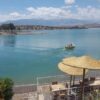
 Jet Ski au Lac Lalla Takerkoust août 24, 2023
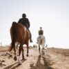
- How Booking a horseback riding excursion in ? août 7, 2023
- Balade à cheval à Marrakech août 7, 2023